The Route
There are two valid routes that can be taken for the Double. For many years up to 2009 the SDW route took in Warnford village. Then a temporary route was added and took in Exton village and a sharp climb up Old Winchester Hill. This then became the official route of the National Park’s SDW. We shall refer to them as the Classic (i.e Warnford) and Current (i.e Old Winchester Hill) routes.
The current ‘Old Winchester Hill’ route is 2.3 x 2 = 4.6 miles longer and 150 x 2 = 300 feet more of climbing. Depending on how fast a rider you are it can add an extra ½ hour in total to the double.
As I say both routes are valid but we encourage you to use the Current ‘Old Winchester Hill’ route. The hall of fame will indicate what route was taken. We understand that you may want to compare your previous time on the Classic route or even to previous rides by the old masters! Map below shows the route differences
The route for the Double is the ‘Riders Route’ which differs from the walkers route, which uses footpaths in a few places, while the cycle route uses bridleways throughout, so be careful not to get caught out with some signage.
We are providing gpx files for each direction for the Current and Classic route. We have split them into single way files as some devices do not like traversing over the same route in the opposite directions. If you are not starting at Winchester or Eastbourne I can recommend GPS Track Editor to create your gpx files from ours.
Updated routes as of 17/07/2022. We have adjusted the route through Queen Elizabeth Country Park to reflect the signage and official route as indicated on the National Park website. There are 3 versions on various maps, but this is the correct way to go through the Park.
GPX Downloads
Updated routes as of 17/07/2022. We have adjusted the route through Queen Elizabeth Country Park to reflect the official signage and National Park website. There are 3 versions on various maps — this is the correct way through the Park.
- Current Route – Winchester to Eastbourne
- Current Route – Eastbourne to Winchester
- Classic Route – Winchester to Eastbourne
- Classic Route – Eastbourne to Winchester
Where Do I Start?
Actually you can start anywhere you like, but most people start in Winchester. This means the last 1/4 is on the perceived easier section. i.e heading back into Winchester. Funnily enough there is just a much climbing on either half of the South Downs Way, but most will agree the Winchester/Amberly section is easier, certainly helped by some road sections. See above for elevation profile. So you can start in Winchester or Eastbourne or say halfway, as long as you traverse the South Downs Way twice, it’s all legal..
If you are going Alpine and starting half way, no cheating and taking supplies from your car. However, it would be a good idea to have emergency supplies available, and then you will be doing a Self Supported ride if you use them.
Official Start — Winchester
The King Alfred Statue marks the start point. Postcode: SO23 9BE. You can't miss it.
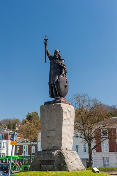
In 2017 the SDW was given an official start at the National Trust's City Mill, about 100 yards from the statue. For the Double we use the King Alfred Statue.
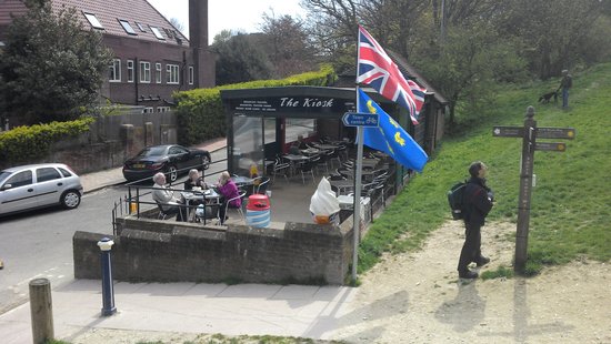
Official Midpoint / End — Eastbourne
The official turnaround in Eastbourne is The Kiosk Café, address: Foyle Way, BN20 7XL.
The Profile
There are very few level sections - it's almost always climbing or descending. All climbs are rideable but some are stiff. The rivers are always close to sea level, and major roads pass through handy gaps, so when you cross one, expect climbing ahead.
Key Navigation Point
Learn the major turns. In particular, watch for this right turn when heading eastbound - your eye is drawn to the trail ahead, and even with a gate and signage it's easy to miss, especially at night.
Boomtown Fair
Every year in early August the Boomtown Fair music festival occupies land near Winchester on the SDW. Check dates and allow extra days either side for build-up and tear-down. A signed diversion is in place, though signage can be hard to spot at night.